


A snowy start to May is set to continue in Colorado, though upcoming waves of wintery weather should favor a different part of the state opposed to other recent storms.
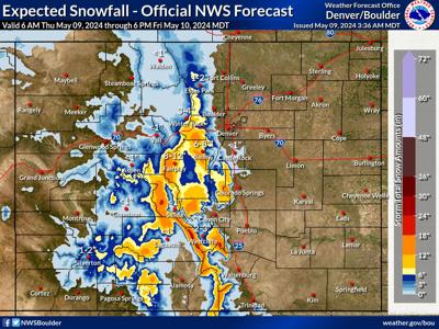
Mapping from the National Weather Service shows that up to two feet of snow could land in limited areas of some of Colorado's central and southern mountain peaks through Friday evening, with heaviest totals centered around the Sangre de Cristo range. This is in contrast to snow that's fallen over the past several days, which has dropped the deepest totals in the northern part of the state.
Where things really get interesting, however, is with the 'high-end' one-in-10-chance snowfall forecast. In this scenario, up to 36 inches of snow could fall in a few select areas, with widespread totals of at least a foot in the central and southern mountains.

The 'high-end' one-in-10-chance snowfall forecast. Map Credit: National Weather Service.
Lightning storms will also be possible during this time. The National Weather Service has also noted that a cooler, wetter trend is expected to continue through the weekend.
Mountain forecasting service OpenSnow reports that Echo Mountain and Monarch will see the highest snow totals among the state's resorts over the next five days. While both of those spots are closed for the season, decent snow should fall at Arapahoe Basin and Loveland, as well.
One side effect of all of this snow could be a boost to the Medano Creek attraction at the Great Sand Dunes, which often relies on a snowy spring to reach higher levels of flow. This much snow in the Sangre de Cristos this late in the season will definitely have an impact, potentially making the scene more impressive and lengthening how long the creek remains present, especially if the snowy trend continues.


(0) comments
Welcome to the discussion.
Log In
Keep it Clean. Please avoid obscene, vulgar, lewd, racist or sexually-oriented language.
PLEASE TURN OFF YOUR CAPS LOCK.
Don't Threaten. Threats of harming another person will not be tolerated.
Be Truthful. Don't knowingly lie about anyone or anything.
Be Nice. No racism, sexism or any sort of -ism that is degrading to another person.
Be Proactive. Use the 'Report' link on each comment to let us know of abusive posts.
Share with Us. We'd love to hear eyewitness accounts, the history behind an article.