
It’s easy to see the appeal of some trails, especially when they lead to an awe-inspiring sight. A weekend drive to Boulder’s Chautauqua Park entails a sometimes-lengthy search for a parking spot. And the hike to the Royal Arch sometimes means stopping for hikers coming through narrow passages – on our recent trip we thought a traffic light might be appropriate. But always, we’re left breathless by the rock bending high in the woods at a stunning overlook.
The relentless ascent also takes the breath away. The climb starts immediately on Chautauqua Trail, up through the meadow where the city’s famous Flatirons loom – the slabs angling high over timberline. Pass the spurs for about a half-mile until you reach the post pointing left for the Bluebell-Baird Trail. Continue down to a picnic area, finding the sign for the Royal Arch that points southwest into the forest.

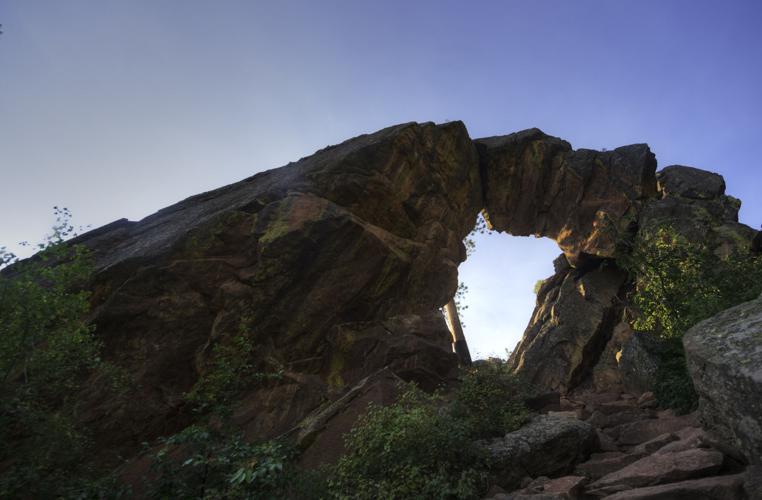
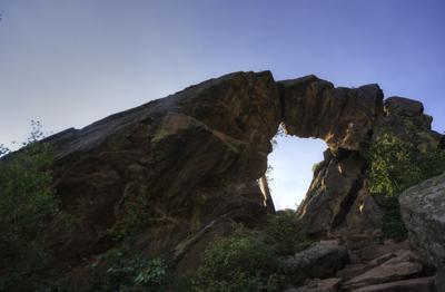
The Royal Arch sits at 6,920 feet in the forest above Chautauqua Park. Photo Credit: Seth Boster
Take a breather at the creek. From here, the climb is steep and harsh for nearly a full mile. The easy-to-follow path is formed by steps that rise and switchback through boulder fields. This is no Manitou Incline, but it makes sense the trail is popular among training runners. The heart beats and the quads burn and the vistas open up through the trees: the town, its reservoirs, the University of Colorado at Boulder campus and the foothills spilling into the far plains. At about the 1.30-mile mark of the trip, it seems you’ve reached the high point at Sentinel Pass. But the high point is at the arch, and to reach it you must scramble down some rocks before climbing again. On the final push, people are surprised to look up from their struggle and suddenly see the arch joining the sky. “There it is!” we heard a couple remark. Under the arch, from where the views are best, we heard someone rightly ask: “How does that happen?”
Trip log: 3.5 miles round trip (out and back), 1,220-foot total elevation gain, 6,920 feet max
Difficulty: Difficult
Getting there: From Colorado Springs, go north on Interstate 25 and catch U.S. 36 west toward Boulder. Exit for Baseline Road and turn left on the road, proceeding 1.4 miles to Chautauqua Park.
FYI: Dogs on leash. Hikers only.


(0) comments
Welcome to the discussion.
Log In
Keep it Clean. Please avoid obscene, vulgar, lewd, racist or sexually-oriented language.
PLEASE TURN OFF YOUR CAPS LOCK.
Don't Threaten. Threats of harming another person will not be tolerated.
Be Truthful. Don't knowingly lie about anyone or anything.
Be Nice. No racism, sexism or any sort of -ism that is degrading to another person.
Be Proactive. Use the 'Report' link on each comment to let us know of abusive posts.
Share with Us. We'd love to hear eyewitness accounts, the history behind an article.